


SityTrail - Aressy-Plateau d' Aressy N° 20 - nouveau tracé

mitch1952
Gebruiker
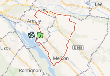

Lengte
8,1 km

Max. hoogte
251 m

Positief hoogteverschil
78 m
Km-Effort
9,2 km

Min. hoogte
186 m

Negatief hoogteverschil
76 m
Boucle
Ja
Datum van aanmaak :
2021-03-14 17:33:15.454
Laatste wijziging :
2022-06-08 10:40:09.876
2h05
Moeilijkheid : Gemakkelijk

Gratisgps-wandelapplicatie
 SityTrail
IGN / Geografische instituten
SityTrail Plus
De wereld gaat voor u open
Over ons
Tocht Te voet van 8,1 km beschikbaar op Nieuw-Aquitanië, Pyrénées-Atlantiques, Aressy. Deze tocht wordt voorgesteld door mitch1952.
Plaatsbepaling
Land:
France
Regio :
Nieuw-Aquitanië
Departement/Provincie :
Pyrénées-Atlantiques
Gemeente :
Aressy
Locatie:
Unknown
Vertrek:(Dec)
Vertrek:(UTM)
716921 ; 4794517 (30T) N.
Opmerkingen