


2021-03-20_17h11m43_Gomer

mitch1952
Gebruiker
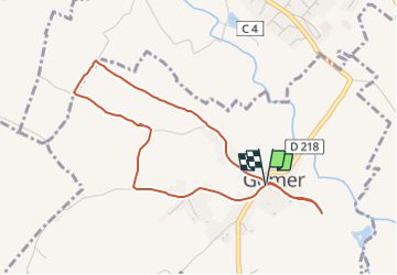

Lengte
4,4 km

Max. hoogte
305 m

Positief hoogteverschil
28 m
Km-Effort
4,8 km

Min. hoogte
285 m

Negatief hoogteverschil
28 m
Boucle
Ja
Datum van aanmaak :
2021-03-20 16:11:43.433
Laatste wijziging :
2022-06-08 10:49:31.641
1h05
Moeilijkheid : Gemakkelijk

Gratisgps-wandelapplicatie
 SityTrail
IGN / Geografische instituten
SityTrail Plus
De wereld gaat voor u open
Over ons
Tocht Te voet van 4,4 km beschikbaar op Nieuw-Aquitanië, Pyrénées-Atlantiques, Gomer. Deze tocht wordt voorgesteld door mitch1952.
Plaatsbepaling
Land:
France
Regio :
Nieuw-Aquitanië
Departement/Provincie :
Pyrénées-Atlantiques
Gemeente :
Gomer
Locatie:
Unknown
Vertrek:(Dec)
Vertrek:(UTM)
728125 ; 4792385 (30T) N.
Opmerkingen