


Lanloup

91eric91
Gebruiker

Lengte
8,5 km

Max. hoogte
99 m

Positief hoogteverschil
164 m
Km-Effort
10,6 km

Min. hoogte
9 m

Negatief hoogteverschil
165 m
Boucle
Ja
Datum van aanmaak :
2021-03-21 14:09:04.0
Laatste wijziging :
2021-03-21 16:13:56.079
2h04
Moeilijkheid : Onbekend

Gratisgps-wandelapplicatie
 SityTrail
IGN / Geografische instituten
SityTrail Plus
De wereld gaat voor u open
Over ons
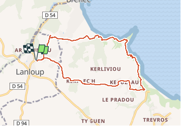
Tocht Stappen van 8,5 km beschikbaar op Bretagne, Côtes-d'Armor, Lanloup. Deze tocht wordt voorgesteld door 91eric91.
Plaatsbepaling
Land:
France
Regio :
Bretagne
Departement/Provincie :
Côtes-d'Armor
Gemeente :
Lanloup
Locatie:
Unknown
Vertrek:(Dec)
Vertrek:(UTM)
502674 ; 5395623 (30U) N.
Opmerkingen