


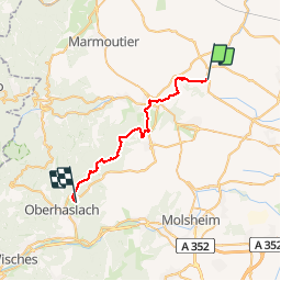
Circuit SA Wintzenheim - Oberhaslach

Tourisme Equestre Alsace
Promouvoir le Tourisme Equestre en Alsace GUIDE+

Lengte
26 km

Max. hoogte
431 m

Positief hoogteverschil
624 m
Km-Effort
34 km

Min. hoogte
194 m

Negatief hoogteverschil
567 m
Boucle
Neen
Datum van aanmaak :
2015-08-25 00:00:00.0
Laatste wijziging :
2019-01-10 23:16:21.183
4h15
Moeilijkheid : Moeilijk

Gratisgps-wandelapplicatie
 SityTrail
IGN / Geografische instituten
SityTrail Plus
De wereld gaat voor u open
Over ons
Tocht Paardrijden van 26 km beschikbaar op Grand Est, Bas-Rhin, Wintzenheim-Kochersberg. Deze tocht wordt voorgesteld door Tourisme Equestre Alsace.
Foto's

POI's


Plaatsbepaling
Land:
France
Regio :
Grand Est
Departement/Provincie :
Bas-Rhin
Gemeente :
Wintzenheim-Kochersberg
Locatie:
Unknown
Vertrek:(Dec)
Vertrek:(UTM)
390519 ; 5390564 (32U) N.
Opmerkingen