


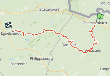
Chemin Chateaux 01 Obersteinbach Eguelshardt

Tourisme Equestre Alsace
Promouvoir le Tourisme Equestre en Alsace GUIDE+

Lengte
28 km

Max. hoogte
472 m

Positief hoogteverschil
695 m
Km-Effort
37 km

Min. hoogte
216 m

Negatief hoogteverschil
659 m
Boucle
Neen
Datum van aanmaak :
2021-03-26 14:58:27.006
Laatste wijziging :
2021-03-26 15:01:44.7
4h50
Moeilijkheid : Moeilijk

Gratisgps-wandelapplicatie
 SityTrail
IGN / Geografische instituten
SityTrail Plus
De wereld gaat voor u open
Over ons
Tocht Paardrijden van 28 km beschikbaar op Grand Est, Bas-Rhin, Obersteinbach. Deze tocht wordt voorgesteld door Tourisme Equestre Alsace.
Foto's

POI's


Plaatsbepaling
Land:
France
Regio :
Grand Est
Departement/Provincie :
Bas-Rhin
Gemeente :
Obersteinbach
Locatie:
Unknown
Vertrek:(Dec)
Vertrek:(UTM)
404317 ; 5432257 (32U) N.
Opmerkingen