


Cap de Pède

mitch1952
Gebruiker
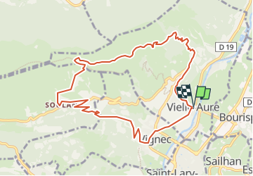

Lengte
11,1 km

Max. hoogte
1609 m

Positief hoogteverschil
816 m
Km-Effort
22 km

Min. hoogte
794 m

Negatief hoogteverschil
817 m
Boucle
Ja
Datum van aanmaak :
2021-03-28 10:34:30.751
Laatste wijziging :
2022-06-08 12:49:18.904
4h59
Moeilijkheid : Medium

Gratisgps-wandelapplicatie
 SityTrail
IGN / Geografische instituten
SityTrail Plus
De wereld gaat voor u open
Over ons
Tocht Te voet van 11,1 km beschikbaar op Occitanië, Hautes-Pyrénées, Vielle-Aure. Deze tocht wordt voorgesteld door mitch1952.
Plaatsbepaling
Land:
France
Regio :
Occitanië
Departement/Provincie :
Hautes-Pyrénées
Gemeente :
Vielle-Aure
Locatie:
Unknown
Vertrek:(Dec)
Vertrek:(UTM)
281530 ; 4745359 (31T) N.
Opmerkingen