


20210614- Etape 22- Lectoure- Marsolan

ghislainem
Gebruiker
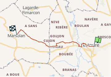

Lengte
9,1 km

Max. hoogte
189 m

Positief hoogteverschil
141 m
Km-Effort
11 km

Min. hoogte
76 m

Negatief hoogteverschil
153 m
Boucle
Neen
Datum van aanmaak :
2021-03-29 17:09:10.078
Laatste wijziging :
2021-05-03 14:46:23.7
2h30
Moeilijkheid : Gemakkelijk

Gratisgps-wandelapplicatie
 SityTrail
IGN / Geografische instituten
SityTrail Plus
De wereld gaat voor u open
Over ons
Tocht Te voet van 9,1 km beschikbaar op Occitanië, Gers, Lectoure. Deze tocht wordt voorgesteld door ghislainem.
Plaatsbepaling
Land:
France
Regio :
Occitanië
Departement/Provincie :
Gers
Gemeente :
Lectoure
Locatie:
Unknown
Vertrek:(Dec)
Vertrek:(UTM)
309476 ; 4867268 (31T) N.
Opmerkingen