


Etap1

LauVan
Gebruiker
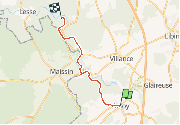

Lengte
7,7 km

Max. hoogte
393 m

Positief hoogteverschil
140 m
Km-Effort
9,7 km

Min. hoogte
310 m

Negatief hoogteverschil
174 m
Boucle
Neen
Datum van aanmaak :
2021-04-07 12:55:32.473
Laatste wijziging :
2021-04-07 14:41:59.682
1h46
Moeilijkheid : Heel gemakkelijk

Gratisgps-wandelapplicatie
 SityTrail
IGN / Geografische instituten
SityTrail Plus
De wereld gaat voor u open
Over ons
Tocht Stappen van 7,7 km beschikbaar op Wallonië, Luxemburg, Libin. Deze tocht wordt voorgesteld door LauVan.
Plaatsbepaling
Land:
Belgium
Regio :
Wallonië
Departement/Provincie :
Luxemburg
Gemeente :
Libin
Locatie:
Anloy
Vertrek:(Dec)
Vertrek:(UTM)
659336 ; 5535457 (31U) N.
Opmerkingen