


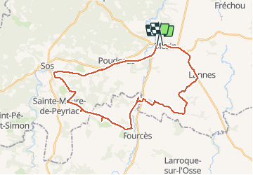
circuit VTT Mezin-voie verte Sos-Ste Maure de Peyriac-Fources-Villeneuve de Mezin-Lannes-Mezin

Forsans
Gebruiker

Lengte
36 km

Max. hoogte
170 m

Positief hoogteverschil
454 m
Km-Effort
42 km

Min. hoogte
63 m

Negatief hoogteverschil
431 m
Boucle
Neen
Datum van aanmaak :
2021-04-08 12:09:32.286
Laatste wijziging :
2021-04-08 17:43:31.781
2h27
Moeilijkheid : Gemakkelijk

Gratisgps-wandelapplicatie
 SityTrail
IGN / Geografische instituten
SityTrail Plus
De wereld gaat voor u open
Over ons
Tocht Mountainbike van 36 km beschikbaar op Nieuw-Aquitanië, Lot-et-Garonne, Mézin. Deze tocht wordt voorgesteld door Forsans.
Beschrijving
circuit chemin et route
Plaatsbepaling
Land:
France
Regio :
Nieuw-Aquitanië
Departement/Provincie :
Lot-et-Garonne
Gemeente :
Mézin
Locatie:
Unknown
Vertrek:(Dec)
Vertrek:(UTM)
279622 ; 4881743 (31T) N.
Opmerkingen