


J C G

horace30900
Gebruiker
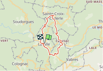

Lengte
13,8 km

Max. hoogte
599 m

Positief hoogteverschil
471 m
Km-Effort
20 km

Min. hoogte
213 m

Negatief hoogteverschil
472 m
Boucle
Ja
Datum van aanmaak :
2014-12-10 00:00:00.0
Laatste wijziging :
2014-12-10 00:00:00.0
--
Moeilijkheid : Medium

Gratisgps-wandelapplicatie
 SityTrail
IGN / Geografische instituten
SityTrail Plus
De wereld gaat voor u open
Over ons
Tocht Stappen van 13,8 km beschikbaar op Occitanië, Gard, Lasalle. Deze tocht wordt voorgesteld door horace30900.
Beschrijving
Randonnée au coeur des Cévennes 18 km
Plaatsbepaling
Land:
France
Regio :
Occitanië
Departement/Provincie :
Gard
Gemeente :
Lasalle
Locatie:
Unknown
Vertrek:(Dec)
Vertrek:(UTM)
568521 ; 4877316 (31T) N.
Opmerkingen