


L'ADARRE

DECHAMPD
Gebruiker

Lengte
11,9 km

Max. hoogte
450 m

Positief hoogteverschil
573 m
Km-Effort
19,5 km

Min. hoogte
164 m

Negatief hoogteverschil
573 m
Boucle
Ja
Datum van aanmaak :
2019-01-14 17:35:50.424
Laatste wijziging :
2019-01-14 17:35:50.458
4h03
Moeilijkheid : Gemakkelijk

Gratisgps-wandelapplicatie
 SityTrail
IGN / Geografische instituten
SityTrail Plus
De wereld gaat voor u open
Over ons
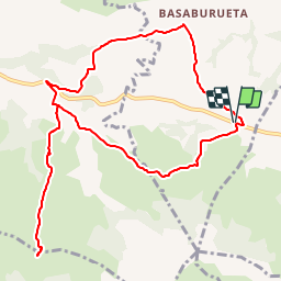
Tocht Stappen van 11,9 km beschikbaar op Nieuw-Aquitanië, Pyrénées-Atlantiques, Mendionde. Deze tocht wordt voorgesteld door DECHAMPD.
Beschrijving
Départ de la base de loisirs, jusqu'au col de Chancho sans montée au sommet de l'Adarre, puis retour par le nord et une partie du chemin de Conpostelle


Plaatsbepaling
Land:
France
Regio :
Nieuw-Aquitanië
Departement/Provincie :
Pyrénées-Atlantiques
Gemeente :
Mendionde
Locatie:
Unknown
Vertrek:(Dec)
Vertrek:(UTM)
639275 ; 4796600 (30T) N.
Opmerkingen