


Maastricht 13km?

wandelgidszuidlimburg
Gebruiker
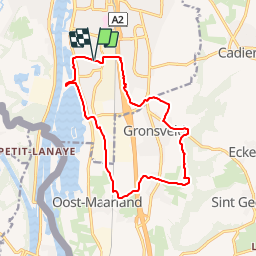

Lengte
12,9 km

Max. hoogte
109 m

Positief hoogteverschil
109 m
Km-Effort
14,4 km

Min. hoogte
43 m

Negatief hoogteverschil
110 m
Boucle
Ja
Datum van aanmaak :
2014-12-10 00:00:00.0
Laatste wijziging :
2014-12-10 00:00:00.0
--
Moeilijkheid : Onbekend

Gratisgps-wandelapplicatie
 SityTrail
IGN / Geografische instituten
SityTrail Plus
De wereld gaat voor u open
Over ons
Tocht Stappen van 12,9 km beschikbaar op Limburg, Onbekend, Maastricht. Deze tocht wordt voorgesteld door wandelgidszuidlimburg.
Beschrijving
More information on : http://www.wandelgidszuidlimburg.com


Plaatsbepaling
Land:
Netherlands
Regio :
Limburg
Departement/Provincie :
Onbekend
Gemeente :
Maastricht
Locatie:
Unknown
Vertrek:(Dec)
Vertrek:(UTM)
690857 ; 5633990 (31U) N.
Opmerkingen
Très belle boucle. Juste une petite déviation suite à la disparition d'un sentier avec la construction de 2 usines.