


SityTrail - Trace reco épurée Aucun Cauraduque

mitch1952
Gebruiker
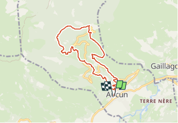

Lengte
8,7 km

Max. hoogte
1472 m

Positief hoogteverschil
590 m
Km-Effort
16,6 km

Min. hoogte
872 m

Negatief hoogteverschil
594 m
Boucle
Ja
Datum van aanmaak :
2021-05-05 16:40:10.381
Laatste wijziging :
2022-06-08 13:28:43.798
3h45
Moeilijkheid : Gemakkelijk

Gratisgps-wandelapplicatie
 SityTrail
IGN / Geografische instituten
SityTrail Plus
De wereld gaat voor u open
Over ons
Tocht Te voet van 8,7 km beschikbaar op Occitanië, Hautes-Pyrénées, Aucun. Deze tocht wordt voorgesteld door mitch1952.
Plaatsbepaling
Land:
France
Regio :
Occitanië
Departement/Provincie :
Hautes-Pyrénées
Gemeente :
Aucun
Locatie:
Unknown
Vertrek:(Dec)
Vertrek:(UTM)
728759 ; 4761665 (30T) N.
Opmerkingen