


Wikiloc - shared-route (20)

AnneCecile
Gebruiker
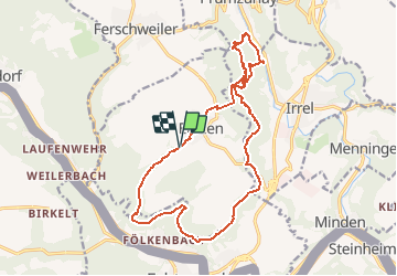

Lengte
16,4 km

Max. hoogte
344 m

Positief hoogteverschil
404 m
Km-Effort
22 km

Min. hoogte
192 m

Negatief hoogteverschil
406 m
Boucle
Ja
Datum van aanmaak :
2021-05-08 12:19:02.201
Laatste wijziging :
2021-05-08 12:27:12.703
--
Moeilijkheid : Heel gemakkelijk

Gratisgps-wandelapplicatie
 SityTrail
IGN / Geografische instituten
SityTrail Plus
De wereld gaat voor u open
Over ons
Tocht Trail van 16,4 km beschikbaar op Rijnland-Palts, Eifelkreis Bitburg-Prüm, Ernzen. Deze tocht wordt voorgesteld door AnneCecile.
Plaatsbepaling
Land:
Germany
Regio :
Rijnland-Palts
Departement/Provincie :
Eifelkreis Bitburg-Prüm
Gemeente :
Ernzen
Locatie:
Unknown
Vertrek:(Dec)
Vertrek:(UTM)
314392 ; 5523911 (32U) N.
Opmerkingen