Tocht Mountainbike Aillianville - Circuit de la grande voie - Aillianville - Photo

Circuit de la grande voie - Aillianville

 delestrai
delestrai

Gebruiker

© OpenStreetMap contributors
Lengte
Lengte
13,8 km
Max. hoogte
Max. hoogte
432 m
Positief hoogteverschil
146 m
Km-Effort
Km-Effort  
15,8 km
Min. hoogte
Min. hoogte
391 m
Negatief hoogteverschil
146 m
Boucle
Boucle
Ja
Datum van aanmaak :
2021-05-09 15:58:03.692
Laatste wijziging :
2021-06-01 15:47:34.297

(0 Bericht)

Mountainbike
Mountainbike
1h05
Moeilijkheid : Gemakkelijk

Scan deze QR-code om de tocht te openen in de SityTrail-applicatie

Gratisgps-wandelapplicatie

Logo SityTrail SityTrail

IGN / Geografische instituten

SityTrail uit de App Store downloaden SityTrail uit Google Play downloaden

Logo SityTrail SityTrail World

De wereld gaat voor u open

SityTrail uit de App Store downloaden SityTrail uit Google Play downloaden SityTrail op Huawei AppGallery downloaden

Over ons

Tocht Mountainbike van 13,8 km beschikbaar op Grand Est, Haute-Marne, Aillianville. Deze tocht wordt voorgesteld door delestrai.

Beschrijving

voir fiche d'information www.tourisme-hautemarne.com N°11

Hoogteprofiel

Foto's

Plaatsbepaling

Land:
France
Regio :
Grand Est
Departement/Provincie :
Haute-Marne
Gemeente :
Aillianville
Locatie:
Unknown
Vertrek:(UTM)
683629 ; 5356993 (31U) N.

Wandeltochten in de omgeving

Tocht Stappen Liffol-le-Petit - jeudi liffol le petit  - Photo
Stappen
lamiche88

Stappen

Gemakkelijk
Liffol-le-Petit, Grand Est, Haute-Marne, France
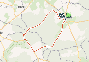
15,6 km | 18,8 km-effort
3h 28min
Ja


Sluiten
Mijn abonnementen