


SityTrail - Les Encanaux

ARPF1
Gebruiker
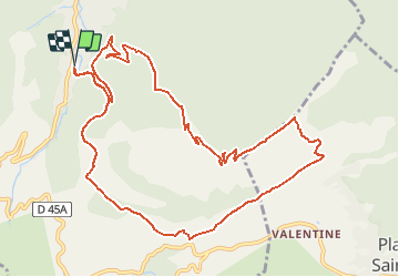

Lengte
13,4 km

Max. hoogte
803 m

Positief hoogteverschil
600 m
Km-Effort
21 km

Min. hoogte
244 m

Negatief hoogteverschil
600 m
Boucle
Ja
Datum van aanmaak :
2021-05-12 10:08:38.354
Laatste wijziging :
2021-05-12 10:17:46.562
4h51
Moeilijkheid : Medium

Gratisgps-wandelapplicatie
 SityTrail
IGN / Geografische instituten
SityTrail Plus
De wereld gaat voor u open
Over ons
Tocht Stappen van 13,4 km beschikbaar op Provence-Alpes-Côte d'Azur, Bouches-du-Rhône, Auriol. Deze tocht wordt voorgesteld door ARPF1.
Plaatsbepaling
Land:
France
Regio :
Provence-Alpes-Côte d'Azur
Departement/Provincie :
Bouches-du-Rhône
Gemeente :
Auriol
Locatie:
Unknown
Vertrek:(Dec)
Vertrek:(UTM)
715594 ; 4803194 (31T) N.
Opmerkingen