


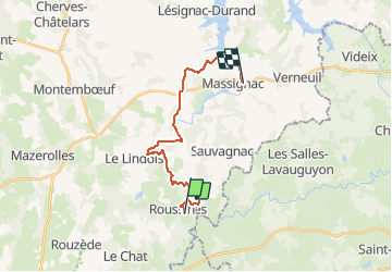
T02-Roussines à Massignac

topolino
Gebruiker

Lengte
17,4 km

Max. hoogte
282 m

Positief hoogteverschil
279 m
Km-Effort
21 km

Min. hoogte
192 m

Negatief hoogteverschil
288 m
Boucle
Neen
Datum van aanmaak :
2021-05-17 15:10:23.008
Laatste wijziging :
2021-05-17 15:10:23.008
--
Moeilijkheid : Onbekend

Gratisgps-wandelapplicatie
 SityTrail
IGN / Geografische instituten
SityTrail Plus
De wereld gaat voor u open
Over ons
Tocht Mountainbike van 17,4 km beschikbaar op Nieuw-Aquitanië, Charente, Roussines. Deze tocht wordt voorgesteld door topolino.
Plaatsbepaling
Land:
France
Regio :
Nieuw-Aquitanië
Departement/Provincie :
Charente
Gemeente :
Roussines
Locatie:
Unknown
Vertrek:(Dec)
Vertrek:(UTM)
315100 ; 5065886 (31T) N.
Opmerkingen