


J2bis - depuis Mt Lozere

aeldin
Gebruiker
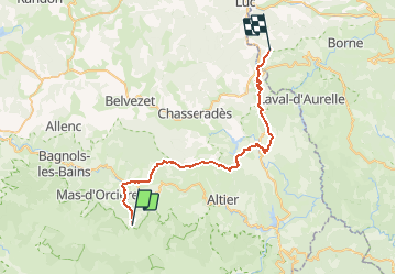

Lengte
37 km

Max. hoogte
1418 m

Positief hoogteverschil
984 m
Km-Effort
51 km

Min. hoogte
843 m

Negatief hoogteverschil
1185 m
Boucle
Neen
Datum van aanmaak :
2021-05-17 19:37:49.892
Laatste wijziging :
2021-05-17 19:42:36.733
--
Moeilijkheid : Heel gemakkelijk

Gratisgps-wandelapplicatie
 SityTrail
IGN / Geografische instituten
SityTrail Plus
De wereld gaat voor u open
Over ons
Tocht Paard van 37 km beschikbaar op Occitanië, Lozère, Cubières. Deze tocht wordt voorgesteld door aeldin.
Plaatsbepaling
Land:
France
Regio :
Occitanië
Departement/Provincie :
Lozère
Gemeente :
Cubières
Locatie:
Unknown
Vertrek:(Dec)
Vertrek:(UTM)
559554 ; 4922422 (31T) N.
Opmerkingen