


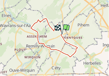
Créhem 12kms (Dén P 175m)

alain62rando
Gebruiker

Lengte
12 km

Max. hoogte
136 m

Positief hoogteverschil
175 m
Km-Effort
14,3 km

Min. hoogte
47 m

Negatief hoogteverschil
173 m
Boucle
Ja
Datum van aanmaak :
2021-05-21 06:29:49.208
Laatste wijziging :
2021-05-23 14:36:28.022
2h35
Moeilijkheid : Medium

Gratisgps-wandelapplicatie
 SityTrail
IGN / Geografische instituten
SityTrail Plus
De wereld gaat voor u open
Over ons
Tocht Stappen van 12 km beschikbaar op Hauts-de-France, Pas-de-Calais, Remilly-Wirquin. Deze tocht wordt voorgesteld door alain62rando.
Beschrijving
Départ arrêt de bus route de Remilly-Wirquin
Plaatsbepaling
Land:
France
Regio :
Hauts-de-France
Departement/Provincie :
Pas-de-Calais
Gemeente :
Remilly-Wirquin
Locatie:
Unknown
Vertrek:(Dec)
Vertrek:(UTM)
442690 ; 5614102 (31U) N.
Opmerkingen