


2021-05-24_10h37m58_balade 24 Avril 18

gilbertdu60
Gebruiker
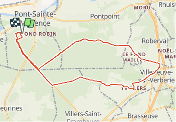

Lengte
20 km

Max. hoogte
202 m

Positief hoogteverschil
277 m
Km-Effort
24 km

Min. hoogte
99 m

Negatief hoogteverschil
277 m
Boucle
Ja
Datum van aanmaak :
2021-05-24 08:37:59.035
Laatste wijziging :
2021-05-24 08:38:00.527

Gratisgps-wandelapplicatie
 SityTrail
IGN / Geografische instituten
SityTrail Plus
De wereld gaat voor u open
Over ons
Tocht van 20 km beschikbaar op Hauts-de-France, Oise, Pont-Sainte-Maxence. Deze tocht wordt voorgesteld door gilbertdu60.
Plaatsbepaling
Land:
France
Regio :
Hauts-de-France
Departement/Provincie :
Oise
Gemeente :
Pont-Sainte-Maxence
Locatie:
Unknown
Vertrek:(Dec)
Vertrek:(UTM)
470633 ; 5460224 (31U) N.
Opmerkingen