


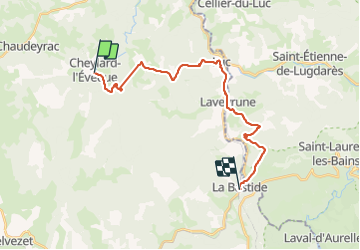
le chemin de Stevenson de cheylard a la bastide

THIOLIER
Gebruiker

Lengte
23 km

Max. hoogte
1249 m

Positief hoogteverschil
696 m
Km-Effort
32 km

Min. hoogte
969 m

Negatief hoogteverschil
800 m
Boucle
Neen
Datum van aanmaak :
2021-05-25 06:26:01.185
Laatste wijziging :
2021-05-25 14:29:41.377
7h26
Moeilijkheid : Medium

Gratisgps-wandelapplicatie
 SityTrail
IGN / Geografische instituten
SityTrail Plus
De wereld gaat voor u open
Over ons
Tocht Stappen van 23 km beschikbaar op Occitanië, Lozère, Cheylard-l'Évêque. Deze tocht wordt voorgesteld door THIOLIER.
Beschrijving
belle etape
Plaatsbepaling
Land:
France
Regio :
Occitanië
Departement/Provincie :
Lozère
Gemeente :
Cheylard-l'Évêque
Locatie:
Unknown
Vertrek:(Dec)
Vertrek:(UTM)
563692 ; 4943978 (31T) N.
Opmerkingen