


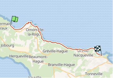
port racine-querqueville

fhascoet
Gebruiker

Lengte
19,9 km

Max. hoogte
63 m

Positief hoogteverschil
258 m
Km-Effort
23 km

Min. hoogte
-2 m

Negatief hoogteverschil
259 m
Boucle
Neen
Datum van aanmaak :
2021-05-25 08:12:52.808
Laatste wijziging :
2021-05-25 14:35:19.757
5h42
Moeilijkheid : Heel gemakkelijk

Gratisgps-wandelapplicatie
 SityTrail
IGN / Geografische instituten
SityTrail Plus
De wereld gaat voor u open
Over ons
Tocht Stappen van 19,9 km beschikbaar op Normandië, Manche, La Hague. Deze tocht wordt voorgesteld door fhascoet.
Plaatsbepaling
Land:
France
Regio :
Normandië
Departement/Provincie :
Manche
Gemeente :
La Hague
Locatie:
Saint-Germain-des-Vaux
Vertrek:(Dec)
Vertrek:(UTM)
579514 ; 5507128 (30U) N.
Opmerkingen