Tocht Paardrijden Condé-en-Normandie - sur les traces des pèlerins du mt st michel  - Photo

sur les traces des pèlerins du mt st michel

 Delphine Besace
Delphine Besace

Gebruiker

© OpenStreetMap contributors
Lengte
Lengte
27 km
Max. hoogte
Max. hoogte
240 m
Positief hoogteverschil
541 m
Km-Effort
Km-Effort  
34 km
Min. hoogte
Min. hoogte
101 m
Negatief hoogteverschil
541 m
Boucle
Boucle
Ja
Datum van aanmaak :
2021-05-26 10:44:13.478
Laatste wijziging :
2021-05-26 10:50:48.299

(0 Bericht)

Paardrijden
Paardrijden
4h29
Moeilijkheid : Moeilijk

Scan deze QR-code om de tocht te openen in de SityTrail-applicatie

Gratisgps-wandelapplicatie

Logo SityTrail SityTrail

IGN / Geografische instituten

SityTrail uit de App Store downloaden SityTrail uit Google Play downloaden

Logo SityTrail SityTrail World

De wereld gaat voor u open

SityTrail uit de App Store downloaden SityTrail uit Google Play downloaden SityTrail op Huawei AppGallery downloaden

Over ons

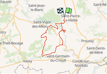
Tocht Paardrijden van 27 km beschikbaar op Normandië, Calvados, Condé-en-Normandie. Deze tocht wordt voorgesteld door Delphine Besace.

Beschrijving

circuit 7 départ et retour à la cour Antéol à saint pierre la vieille

Hoogteprofiel

Plaatsbepaling

Land:
France
Regio :
Normandië
Departement/Provincie :
Calvados
Gemeente :
Condé-en-Normandie
Locatie:
Saint-Pierre-la-Vieille
Vertrek:(UTM)
676570 ; 5421371 (30U) N.

Wandeltochten in de omgeving

Tocht Te voet Condé-en-Normandie - La Chapelle Engerbold - Photo
Te voet
PRO

Te voet

Gemakkelijk
Condé-en-Normandie, Normandië, Calvados, France
4,3 km | 5,8 km-effort
1h 18min
Ja
Tocht Te voet Culey-le-Patry - Le Mouin du Fay - Photo
Te voet
PRO

Te voet

Gemakkelijk
Culey-le-Patry, Normandië, Calvados, France
4,8 km | 6,7 km-effort
1h 31min
Neen
Tocht Te voet Terres de Druance - Le Moulin du Boeuf - Photo
Te voet
PRO

Te voet

Gemakkelijk
Terres de Druance, Normandië, Calvados, France
6,1 km | 7,9 km-effort
1h 47min
Ja
Tocht Te voet Terres de Druance - Tour du Bourg - Photo
Te voet
PRO

Te voet

Gemakkelijk
Terres de Druance, Normandië, Calvados, France
3,3 km | 4,2 km-effort
57min
Ja
Tocht Te voet Condé-en-Normandie - A la Découverte des
Te voet
PRO

Te voet

Gemakkelijk
Condé-en-Normandie, Normandië, Calvados, France
10,4 km | 13,6 km-effort
3h 5min
Ja
Tocht Te voet La Villette - Vers la
Te voet
PRO

Te voet

Gemakkelijk
La Villette, Normandië, Calvados, France
4,5 km | 6,3 km-effort
1h 25min
Ja
Tocht Te voet Condé-en-Normandie - Chemins Creux E - Photo
Te voet
PRO

Te voet

Gemakkelijk
Condé-en-Normandie, Normandië, Calvados, France
6,6 km | 8,2 km-effort
1h 51min
Ja
Tocht Te voet Périgny - Chemins Creux C - Photo
Te voet
PRO

Te voet

Gemakkelijk
Périgny, Normandië, Calvados, France
4,2 km | 5,1 km-effort
1h 10min
Ja
Tocht Te voet Pontécoulant - Chemins Creux A - Photo
Te voet
PRO

Te voet

Gemakkelijk
Pontécoulant, Normandië, Calvados, France
3,8 km | 5,7 km-effort
1h 17min
Ja


Sluiten
Mijn abonnementen