Tocht Stappen Winkel - Winkel-Petit Kohlberg variante - Photo

Winkel-Petit Kohlberg variante

 JCLUTT
JCLUTT

Gebruiker

© OpenStreetMap contributors
Lengte
Lengte
6,8 km
Max. hoogte
Max. hoogte
747 m
Positief hoogteverschil
140 m
Km-Effort
Km-Effort  
8,7 km
Min. hoogte
Min. hoogte
662 m
Negatief hoogteverschil
136 m
Boucle
Boucle
Ja
Datum van aanmaak :
2021-05-27 08:11:19.567
Laatste wijziging :
2021-05-27 08:32:53.323

(0 Bericht)

Stappen
Stappen
1h58
Moeilijkheid : Heel gemakkelijk

Scan deze QR-code om de tocht te openen in de SityTrail-applicatie

Gratisgps-wandelapplicatie

Logo SityTrail SityTrail

IGN / Geografische instituten

SityTrail uit de App Store downloaden SityTrail uit Google Play downloaden

Logo SityTrail SityTrail Plus

De wereld gaat voor u open

SityTrail uit de App Store downloaden SityTrail uit Google Play downloaden SityTrail op Huawei AppGallery downloaden

Over ons

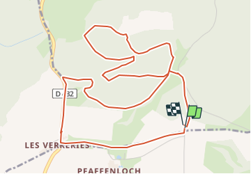
Tocht Stappen van 6,8 km beschikbaar op Grand Est, Haut-Rhin, Winkel. Deze tocht wordt voorgesteld door JCLUTT.

Beschrijving

Petite balade apéritive ou digestive après un excellent repas au Petit Kohlberg ! A conseiller pour son accueil et la qualité du restaurant ! Ne pas oublier de faire un tour à la source de L'Ill et visiter la chapelle de Warth du 14ème siècle à Winkel.

Hoogteprofiel

POI's

POI Winkel - Les Verreries - Photo
JCLUTT
POI Winkel - Calvaire - Photo
JCLUTT
WINKEL 
POI Winkel - Parking - Photo
JCLUTT
WINKEL 
POI Winkel - Cote 738 - Photo
JCLUTT
WINKEL 
POI Winkel - Cote 713 - Photo
JCLUTT
WINKEL 
POI Winkel - Retour sur la route - Photo
JCLUTT

Plaatsbepaling

Land:
France
Regio :
Grand Est
Departement/Provincie :
Haut-Rhin
Gemeente :
Winkel
Locatie:
Unknown
Vertrek:(Dec)
Vertrek:(UTM)
369386 ; 5256000 (32T) N.


Sluiten
Mijn abonnementen