


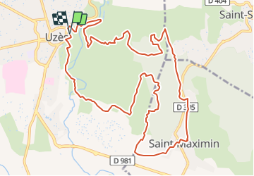
Vallée de l'eure (Uzès)

JMJ42
Gebruiker

Lengte
14,5 km

Max. hoogte
184 m

Positief hoogteverschil
329 m
Km-Effort
18,9 km

Min. hoogte
69 m

Negatief hoogteverschil
329 m
Boucle
Ja
Datum van aanmaak :
2021-05-28 17:58:43.964
Laatste wijziging :
2021-05-28 17:59:31.626
4h17
Moeilijkheid : Moeilijk

Gratisgps-wandelapplicatie
 SityTrail
IGN / Geografische instituten
SityTrail Plus
De wereld gaat voor u open
Over ons
Tocht Stappen van 14,5 km beschikbaar op Occitanië, Gard, Uzès. Deze tocht wordt voorgesteld door JMJ42.
Plaatsbepaling
Land:
France
Regio :
Occitanië
Departement/Provincie :
Gard
Gemeente :
Uzès
Locatie:
Unknown
Vertrek:(Dec)
Vertrek:(UTM)
614061 ; 4874257 (31T) N.
Opmerkingen