


f-drenthe-rondje-diever

gpstracks
Gebruiker
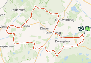

Lengte
48 km

Max. hoogte
23 m

Positief hoogteverschil
233 m
Km-Effort
51 km

Min. hoogte
-1 m

Negatief hoogteverschil
233 m
Boucle
Ja
Datum van aanmaak :
2014-12-10 00:00:00.0
Laatste wijziging :
2014-12-10 00:00:00.0
--
Moeilijkheid : Onbekend

Gratisgps-wandelapplicatie
 SityTrail
IGN / Geografische instituten
SityTrail Plus
De wereld gaat voor u open
Over ons
Tocht Fiets van 48 km beschikbaar op Drenthe, Onbekend, Westerveld. Deze tocht wordt voorgesteld door gpstracks.
Beschrijving
More information on GPStracks.nl : http://www.gpstracks.nl


Plaatsbepaling
Land:
Netherlands
Regio :
Drenthe
Departement/Provincie :
Onbekend
Gemeente :
Westerveld
Locatie:
Unknown
Vertrek:(Dec)
Vertrek:(UTM)
326662 ; 5858109 (32U) N.
Opmerkingen