


st germain camps des loges

adubarry
Gebruiker
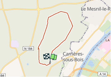

Lengte
6 km

Max. hoogte
88 m

Positief hoogteverschil
58 m
Km-Effort
6,8 km

Min. hoogte
66 m

Negatief hoogteverschil
62 m
Boucle
Ja
Datum van aanmaak :
2021-06-06 13:05:49.618
Laatste wijziging :
2021-06-06 14:41:21.23
1h33
Moeilijkheid : Medium

Gratisgps-wandelapplicatie
 SityTrail
IGN / Geografische instituten
SityTrail Plus
De wereld gaat voor u open
Over ons
Tocht Stappen van 6 km beschikbaar op Île-de-France, Yvelines, Saint-Germain-en-Laye. Deze tocht wordt voorgesteld door adubarry.
Beschrijving
patou
Plaatsbepaling
Land:
France
Regio :
Île-de-France
Departement/Provincie :
Yvelines
Gemeente :
Saint-Germain-en-Laye
Locatie:
Saint-Germain-en-Laye
Vertrek:(Dec)
Vertrek:(UTM)
434201 ; 5418898 (31U) N.
Opmerkingen