


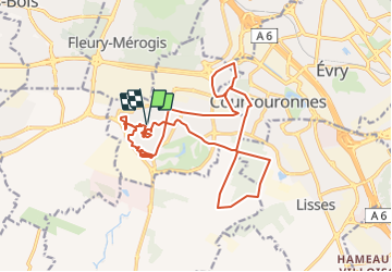
SityTrail - 2021-06-30 Centre Aéré Saint Ex - Sortie longue

Lucquiaud
Gebruiker

Lengte
19,1 km

Max. hoogte
94 m

Positief hoogteverschil
131 m
Km-Effort
21 km

Min. hoogte
73 m

Negatief hoogteverschil
131 m
Boucle
Ja
Datum van aanmaak :
2021-06-30 08:47:30.669
Laatste wijziging :
2021-07-03 09:03:20.245
1h26
Moeilijkheid : Medium

Gratisgps-wandelapplicatie
 SityTrail
IGN / Geografische instituten
SityTrail Plus
De wereld gaat voor u open
Over ons
Tocht Mountainbike van 19,1 km beschikbaar op Île-de-France, Essonne, Bondoufle. Deze tocht wordt voorgesteld door Lucquiaud.
Plaatsbepaling
Land:
France
Regio :
Île-de-France
Departement/Provincie :
Essonne
Gemeente :
Bondoufle
Locatie:
Unknown
Vertrek:(Dec)
Vertrek:(UTM)
453607 ; 5384601 (31U) N.
Opmerkingen