Tocht Te voet Boismont - St-VALERY ... la Pointe du Hourdel.  - Photo

St-VALERY ... la Pointe du Hourdel.

 GerardBouche
GerardBouche

Gebruiker

© OpenStreetMap contributors
Lengte
Lengte
23 km
Max. hoogte
Max. hoogte
30 m
Positief hoogteverschil
110 m
Km-Effort
Km-Effort  
24 km
Min. hoogte
Min. hoogte
-1 m
Negatief hoogteverschil
111 m
Boucle
Boucle
Ja
Datum van aanmaak :
2021-07-08 11:05:58.94
Laatste wijziging :
2021-07-11 16:08:03.312

(0 Bericht)

Te voet
Te voet
5h31
Moeilijkheid : Medium
Mountainbike
Mountainbike
2h26
Moeilijkheid : Heel gemakkelijk
Hybride fiets
Hybride fiets
--
Moeilijkheid : Heel gemakkelijk

Scan deze QR-code om de tocht te openen in de SityTrail-applicatie

Gratisgps-wandelapplicatie

Logo SityTrail SityTrail

IGN / Geografische instituten

SityTrail uit de App Store downloaden SityTrail uit Google Play downloaden

Logo SityTrail SityTrail World

De wereld gaat voor u open

SityTrail uit de App Store downloaden SityTrail uit Google Play downloaden SityTrail op Huawei AppGallery downloaden

Over ons

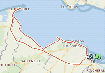
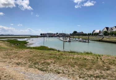
Tocht Te voet van 23 km beschikbaar op Hauts-de-France, Somme, Boismont. Deze tocht wordt voorgesteld door GerardBouche.

Beschrijving

Depuis St -Valery, par le Quai Jeanne d'Arc jusqu'au Cap Hornu. A partir de là, emprunter un petit sentier longeant les "mollières " de la Baie jusqu'à la Pointe du Hourdel ... à marée basse, il est possible d'y observer les phoques !)
Le retour par la piste cyclable de la Baie..

Hoogteprofiel

Foto's

Plaatsbepaling

Land:
France
Regio :
Hauts-de-France
Departement/Provincie :
Somme
Gemeente :
Boismont
Locatie:
Unknown
Vertrek:(UTM)
403816 ; 5558820 (31U) N.

Wandeltochten in de omgeving

Tocht Stappen Saint-Valery-sur-Somme - Balade à Saint-Valéry-sur-Somme - Photo
Stappen
GUIDE
Desrumaux

Stappen

Gemakkelijk
(4)
Saint-Valery-sur-Somme, Hauts-de-France, Somme, France
10,4 km | 12,2 km-effort
2h 41min
Ja
Tocht Stappen Estrébœuf - Circuit de Drancourt - Photo
Stappen
tracegps

Stappen

Medium
(2)
Estrébœuf, Hauts-de-France, Somme, France
6,6 km | 7,4 km-effort
2h 15min
Ja
Tocht Stappen Saint-Valery-sur-Somme - Balade à Saint-Valery sur Somme - Photo
Stappen
tracegps

Stappen

Medium
(3)
Saint-Valery-sur-Somme, Hauts-de-France, Somme, France
7,1 km | 8,6 km-effort
2h 19min
Ja
Tocht Stappen Saint-Valery-sur-Somme - Traversée Baie de Somme 11/08/2021 - Photo
Stappen
GUIDE
R@ph

Stappen

Medium
Saint-Valery-sur-Somme, Hauts-de-France, Somme, France
8,5 km | 8,8 km-effort
2h 0min
Neen
Tocht Stappen Saint-Valery-sur-Somme - w-frankrijk-over-dijken-en-kwelders - Photo
Stappen
gpstracks

Stappen

Heel gemakkelijk
(2)
Saint-Valery-sur-Somme, Hauts-de-France, Somme, France
13,8 km | 14,9 km-effort
Onbekend
Ja
Tocht Mountainbike Saint-Valery-sur-Somme - Gravelot Baie de sommes - Photo
Mountainbike
Jeanlouisbray

Mountainbike

Gemakkelijk
(1)
Saint-Valery-sur-Somme, Hauts-de-France, Somme, France
44 km | 47 km-effort
4h 56min
Ja
Tocht Fiets Le Crotoy - Crotoy - Marquenterre - Photo
Fiets
jacques.moulin@hotmail.com

Fiets

Medium
(1)
Le Crotoy, Hauts-de-France, Somme, France
18,3 km | 19,2 km-effort
1h 8min
Ja
Tocht Stappen Saint-Valery-sur-Somme - Baie de Somme - Photo
Stappen
Greg813

Stappen

Moeilijk
Saint-Valery-sur-Somme, Hauts-de-France, Somme, France
25 km | 27 km-effort
5h 26min
Ja
Tocht Stappen Le Crotoy - Port du crotoy - port de St Valéry sur somme par GR - Photo
Stappen
ash

Stappen

Heel gemakkelijk
(1)
Le Crotoy, Hauts-de-France, Somme, France
12,3 km | 12,7 km-effort
2h 40min
Neen


Sluiten
Mijn abonnementen