Tocht Stappen Bussy-en-Othe - 210725 Bussy en Othe - Photo
 Specialized77
Specialized77

Gebruiker

© OpenStreetMap contributors
Lengte
Lengte
11,4 km
Max. hoogte
Max. hoogte
259 m
Positief hoogteverschil
193 m
Km-Effort
Km-Effort  
13,9 km
Min. hoogte
Min. hoogte
152 m
Negatief hoogteverschil
193 m
Boucle
Boucle
Ja
Datum van aanmaak :
2021-07-25 07:00:12.87
Laatste wijziging :
2022-04-11 14:46:29.26

(0 Bericht)

Stappen
Stappen
3h58
Moeilijkheid : Gemakkelijk

Scan deze QR-code om de tocht te openen in de SityTrail-applicatie

Gratisgps-wandelapplicatie

Logo SityTrail SityTrail

IGN / Geografische instituten

SityTrail uit de App Store downloaden SityTrail uit Google Play downloaden

Logo SityTrail SityTrail World

De wereld gaat voor u open

SityTrail uit de App Store downloaden SityTrail uit Google Play downloaden SityTrail op Huawei AppGallery downloaden

Over ons

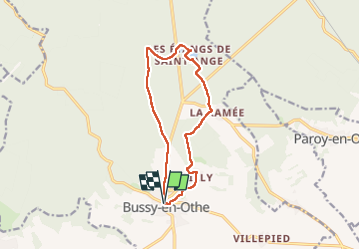
Tocht Stappen van 11,4 km beschikbaar op Bourgondië-Franche-Comté, Yonne, Bussy-en-Othe. Deze tocht wordt voorgesteld door Specialized77.

Beschrijving

Avec Paron rebondir

Hoogteprofiel

Foto's

Plaatsbepaling

Land:
France
Regio :
Bourgondië-Franche-Comté
Departement/Provincie :
Yonne
Gemeente :
Bussy-en-Othe
Locatie:
Unknown
Vertrek:(UTM)
538270 ; 5318589 (31U) N.

Wandeltochten in de omgeving

Tocht Stappen Bussy-en-Othe - Bussy Les étangs de St Ange - Photo
Stappen
papyjv8991

Stappen

Gemakkelijk
Bussy-en-Othe, Bourgondië-Franche-Comté, Yonne, France
7,2 km | 8,3 km-effort
1h 49min
Ja
Tocht Stappen Bussy-en-Othe - st ange - Photo
Stappen
c.chehere

Stappen

Heel gemakkelijk
Bussy-en-Othe, Bourgondië-Franche-Comté, Yonne, France
3,4 km | 3,9 km-effort
1h 13min
Neen
Tocht Stappen Bussy-en-Othe - 3 mai - Photo
Stappen
c.chehere

Stappen

Heel gemakkelijk
Bussy-en-Othe, Bourgondië-Franche-Comté, Yonne, France
2,3 km | 2,6 km-effort
1h 13min
Ja


Sluiten
Mijn abonnementen