


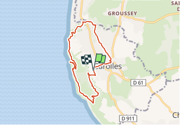
Carolles vallée peintres cabane Vauban

pidjam
Gebruiker

Lengte
7,1 km

Max. hoogte
68 m

Positief hoogteverschil
143 m
Km-Effort
9 km

Min. hoogte
10 m

Negatief hoogteverschil
145 m
Boucle
Ja
Datum van aanmaak :
2021-07-27 09:57:59.654
Laatste wijziging :
2021-08-09 16:18:14.599
2h25
Moeilijkheid : Gemakkelijk

Gratisgps-wandelapplicatie
 SityTrail
IGN / Geografische instituten
SityTrail Plus
De wereld gaat voor u open
Over ons
Tocht Stappen van 7,1 km beschikbaar op Normandië, Manche, Carolles. Deze tocht wordt voorgesteld door pidjam.
Plaatsbepaling
Land:
France
Regio :
Normandië
Departement/Provincie :
Manche
Gemeente :
Carolles
Locatie:
Unknown
Vertrek:(Dec)
Vertrek:(UTM)
605517 ; 5400534 (30U) N.
Opmerkingen