


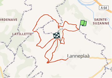

14,4 km | 17,2 km-effort


Gebruiker


Gratisgps-wandelapplicatie
 SityTrail
IGN / Geografische instituten
SityTrail World
De wereld gaat voor u open
Tocht Motorfiets van 21 km beschikbaar op Nieuw-Aquitanië, Pyrénées-Atlantiques, Orthez. Deze tocht wordt voorgesteld door x team .
Stappen
Te voet
Noords wandelen
Stappen
Stappen

Lopen

Mountainbike
Stappen
Stappen