


Castellar_-_Mont_Carpano-11230520-1630248664-877

Renefrt
Gebruiker
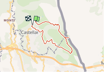

Lengte
7,7 km

Max. hoogte
766 m

Positief hoogteverschil
461 m
Km-Effort
13,9 km

Min. hoogte
324 m

Negatief hoogteverschil
469 m
Boucle
Ja
Datum van aanmaak :
2021-08-29 14:49:36.0
Laatste wijziging :
2021-08-29 14:51:35.089

Gratisgps-wandelapplicatie
 SityTrail
IGN / Geografische instituten
SityTrail Plus
De wereld gaat voor u open
Over ons
Tocht van 7,7 km beschikbaar op Provence-Alpes-Côte d'Azur, Alpes-Maritimes, Castellar. Deze tocht wordt voorgesteld door Renefrt.
Plaatsbepaling
Land:
France
Regio :
Provence-Alpes-Côte d'Azur
Departement/Provincie :
Alpes-Maritimes
Gemeente :
Castellar
Locatie:
Unknown
Vertrek:(Dec)
Vertrek:(UTM)
379263 ; 4851551 (32T) N.
Opmerkingen