


Semoy Bourg

astro45
Gebruiker
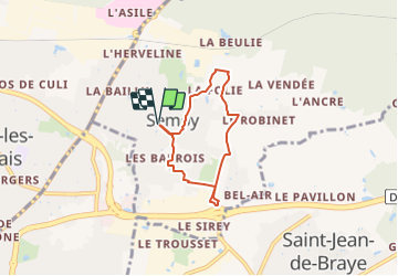

Lengte
4,9 km

Max. hoogte
122 m

Positief hoogteverschil
35 m
Km-Effort
5,4 km

Min. hoogte
104 m

Negatief hoogteverschil
35 m
Boucle
Ja
Datum van aanmaak :
2021-06-13 08:42:40.0
Laatste wijziging :
2021-08-31 07:23:06.27
1h57
Moeilijkheid : Medium

Gratisgps-wandelapplicatie
 SityTrail
IGN / Geografische instituten
SityTrail Plus
De wereld gaat voor u open
Over ons
Tocht Stappen van 4,9 km beschikbaar op Centre-Val de Loire, Loiret, Semoy. Deze tocht wordt voorgesteld door astro45.
Plaatsbepaling
Land:
France
Regio :
Centre-Val de Loire
Departement/Provincie :
Loiret
Gemeente :
Semoy
Locatie:
Unknown
Vertrek:(Dec)
Vertrek:(UTM)
421381 ; 5309414 (31T) N.
Opmerkingen