


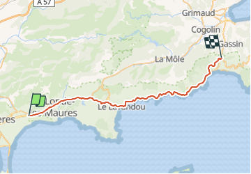
Piste cyclable du littoral

frizou83
Gebruiker

Lengte
40 km

Max. hoogte
113 m

Positief hoogteverschil
628 m
Km-Effort
48 km

Min. hoogte
0 m

Negatief hoogteverschil
519 m
Boucle
Neen
Datum van aanmaak :
2021-09-22 15:58:41.303
Laatste wijziging :
2021-09-22 16:20:31.017
4h00
Moeilijkheid : Gemakkelijk

Gratisgps-wandelapplicatie
 SityTrail
IGN / Geografische instituten
SityTrail Plus
De wereld gaat voor u open
Over ons
Tocht Fiets van 40 km beschikbaar op Provence-Alpes-Côte d'Azur, Var, Hyères. Deze tocht wordt voorgesteld door frizou83.
Plaatsbepaling
Land:
France
Regio :
Provence-Alpes-Côte d'Azur
Departement/Provincie :
Var
Gemeente :
Hyères
Locatie:
Unknown
Vertrek:(Dec)
Vertrek:(UTM)
271318 ; 4778464 (32T) N.
Opmerkingen