


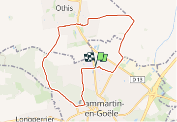
SM_Dammartin-en-Goele-(PR Gérard de NERVAL) 8.4Km

GR77LP
Gebruiker

Lengte
8,4 km

Max. hoogte
170 m

Positief hoogteverschil
100 m
Km-Effort
9,7 km

Min. hoogte
103 m

Negatief hoogteverschil
98 m
Boucle
Ja
Datum van aanmaak :
2021-09-27 17:50:50.297
Laatste wijziging :
2023-11-04 15:09:32.6
2h12
Moeilijkheid : Medium

Gratisgps-wandelapplicatie
 SityTrail
IGN / Geografische instituten
SityTrail Plus
De wereld gaat voor u open
Over ons
Tocht Stappen van 8,4 km beschikbaar op Île-de-France, Seine-et-Marne, Dammartin-en-Goële. Deze tocht wordt voorgesteld door GR77LP.
Beschrijving
https://www.goelerando.fr/
Dammartin-en-Goële 77
Foto's
 8.4Km - Photo 1")
Plaatsbepaling
Land:
France
Regio :
Île-de-France
Departement/Provincie :
Seine-et-Marne
Gemeente :
Dammartin-en-Goële
Locatie:
Unknown
Vertrek:(Dec)
Vertrek:(UTM)
476733 ; 5434635 (31U) N.
Opmerkingen