


Nice Orly

jcm17
Gebruiker

Lengte
700 km

Max. hoogte
2913 m

Positief hoogteverschil
39600 m
Km-Effort
1228 km

Min. hoogte
29 m

Negatief hoogteverschil
39590 m
Boucle
Neen
Datum van aanmaak :
2021-09-26 14:46:23.118
Laatste wijziging :
2021-09-29 09:42:46.256
1h03
Moeilijkheid : Heel gemakkelijk

Gratisgps-wandelapplicatie
 SityTrail
IGN / Geografische instituten
SityTrail Plus
De wereld gaat voor u open
Over ons
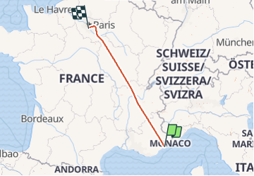
Tocht Vliegtuig van 700 km beschikbaar op Provence-Alpes-Côte d'Azur, Alpes-Maritimes, Antibes. Deze tocht wordt voorgesteld door jcm17.
Plaatsbepaling
Land:
France
Regio :
Provence-Alpes-Côte d'Azur
Departement/Provincie :
Alpes-Maritimes
Gemeente :
Antibes
Locatie:
Unknown
Vertrek:(Dec)
Vertrek:(UTM)
346653 ; 4828770 (32T) N.
Opmerkingen