


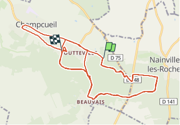
2021-10-02 parcours Journée nature

Lucquiaud
Gebruiker

Lengte
19,6 km

Max. hoogte
126 m

Positief hoogteverschil
248 m
Km-Effort
23 km

Min. hoogte
77 m

Negatief hoogteverschil
253 m
Boucle
Neen
Datum van aanmaak :
2021-10-02 07:22:58.239
Laatste wijziging :
2021-10-02 12:46:48.487
5h23
Moeilijkheid : Heel gemakkelijk

Gratisgps-wandelapplicatie
 SityTrail
IGN / Geografische instituten
SityTrail Plus
De wereld gaat voor u open
Over ons
Tocht Mountainbike van 19,6 km beschikbaar op Île-de-France, Essonne, Champcueil. Deze tocht wordt voorgesteld door Lucquiaud.
Beschrijving
La journée nature du Conseil Départemental
Plaatsbepaling
Land:
France
Regio :
Île-de-France
Departement/Provincie :
Essonne
Gemeente :
Champcueil
Locatie:
Unknown
Vertrek:(Dec)
Vertrek:(UTM)
461103 ; 5372809 (31U) N.
Opmerkingen