


Rsger2021

LouisROGER
Gebruiker GUIDE
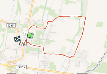

Lengte
4,6 km

Max. hoogte
410 m

Positief hoogteverschil
39 m
Km-Effort
5,1 km

Min. hoogte
394 m

Negatief hoogteverschil
39 m
Boucle
Ja
Datum van aanmaak :
2021-10-05 11:58:55.657
Laatste wijziging :
2021-10-05 13:49:24.446
1h50
Moeilijkheid : Gemakkelijk

Gratisgps-wandelapplicatie
 SityTrail
IGN / Geografische instituten
SityTrail Plus
De wereld gaat voor u open
Over ons
Tocht Stappen van 4,6 km beschikbaar op Nieuw-Aquitanië, Pyrénées-Atlantiques, Ger. Deze tocht wordt voorgesteld door LouisROGER.
Plaatsbepaling
Land:
France
Regio :
Nieuw-Aquitanië
Departement/Provincie :
Pyrénées-Atlantiques
Gemeente :
Ger
Locatie:
Unknown
Vertrek:(Dec)
Vertrek:(UTM)
739327 ; 4793127 (30T) N.
Opmerkingen