


Huhnelmuhle-Belle Vue

GR5 2020
Gebruiker
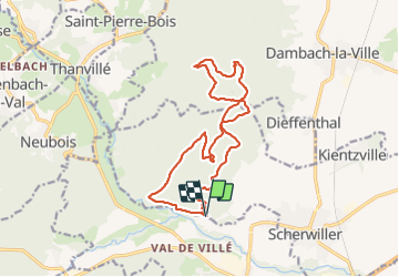

Lengte
15,6 km

Max. hoogte
656 m

Positief hoogteverschil
560 m
Km-Effort
23 km

Min. hoogte
200 m

Negatief hoogteverschil
558 m
Boucle
Ja
Datum van aanmaak :
2021-10-07 12:18:16.373
Laatste wijziging :
2021-10-07 14:49:09.67
2h30
Moeilijkheid : Heel gemakkelijk

Gratisgps-wandelapplicatie
 SityTrail
IGN / Geografische instituten
SityTrail Plus
De wereld gaat voor u open
Over ons
Tocht Trail van 15,6 km beschikbaar op Grand Est, Bas-Rhin, Scherwiller. Deze tocht wordt voorgesteld door GR5 2020.
Plaatsbepaling
Land:
France
Regio :
Grand Est
Departement/Provincie :
Bas-Rhin
Gemeente :
Scherwiller
Locatie:
Unknown
Vertrek:(Dec)
Vertrek:(UTM)
380503 ; 5349794 (32U) N.
Opmerkingen