


rando VTT du 10/10 avec Lolo

dudu79
Gebruiker

Lengte
26 km

Max. hoogte
232 m

Positief hoogteverschil
398 m
Km-Effort
32 km

Min. hoogte
146 m

Negatief hoogteverschil
402 m
Boucle
Ja
Datum van aanmaak :
2021-10-10 05:22:49.923
Laatste wijziging :
2021-10-10 05:22:52.251
2h12
Moeilijkheid : Medium

Gratisgps-wandelapplicatie
 SityTrail
IGN / Geografische instituten
SityTrail Plus
De wereld gaat voor u open
Over ons
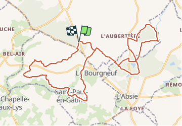
Tocht Mountainbike van 26 km beschikbaar op Nieuw-Aquitanië, Deux-Sèvres, Moncoutant-sur-Sèvre. Deze tocht wordt voorgesteld door dudu79.
Plaatsbepaling
Land:
France
Regio :
Nieuw-Aquitanië
Departement/Provincie :
Deux-Sèvres
Gemeente :
Moncoutant-sur-Sèvre
Locatie:
La Chapelle-Saint-Étienne
Vertrek:(Dec)
Vertrek:(UTM)
682851 ; 5169934 (30T) N.
Opmerkingen