Tocht Te voet Meymac - GR440, jour 1: Meymac à Lieu de bivouac - Photo

GR440, jour 1: Meymac à Lieu de bivouac

 MathieuBourgois
MathieuBourgois

Gebruiker

© OpenStreetMap contributors
Lengte
Lengte
28 km
Max. hoogte
Max. hoogte
927 m
Positief hoogteverschil
688 m
Km-Effort
Km-Effort  
37 km
Min. hoogte
Min. hoogte
641 m
Negatief hoogteverschil
680 m
Boucle
Boucle
Neen
Datum van aanmaak :
2021-10-14 08:02:05.121
Laatste wijziging :
2021-10-14 08:15:13.913

(0 Bericht)

Te voet
Te voet
2h08
Moeilijkheid : Moeilijk

Scan deze QR-code om de tocht te openen in de SityTrail-applicatie

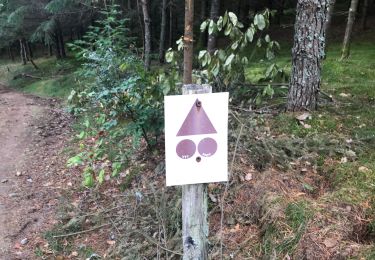
Gratisgps-wandelapplicatie

Logo SityTrail SityTrail

IGN / Geografische instituten

SityTrail uit de App Store downloaden SityTrail uit Google Play downloaden

Logo SityTrail SityTrail World

De wereld gaat voor u open

SityTrail uit de App Store downloaden SityTrail uit Google Play downloaden SityTrail op Huawei AppGallery downloaden

Over ons

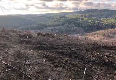
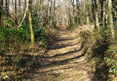
Tocht Te voet van 28 km beschikbaar op Nieuw-Aquitanië, Corrèze, Meymac. Deze tocht wordt voorgesteld door MathieuBourgois.

Beschrijving

-Haut Matrillac 6.7km 240D
-La Saulière 15km et 550D
-Sources de le Corrèze 19km et 620D
-Bonnefond 24km et 670D
-Lieu de bivouac 28km et 680D

Hoogteprofiel

Plaatsbepaling

Land:
France
Regio :
Nieuw-Aquitanië
Departement/Provincie :
Corrèze
Gemeente :
Meymac
Locatie:
Unknown
Vertrek:(UTM)
433418 ; 5042862 (31T) N.

Wandeltochten in de omgeving

Tocht Stappen Meymac - De feuilles en aiguilles - Ambrugeat - Pays de Haute Corrèze  - Photo
Stappen
tracegps

Stappen

Moeilijk
(1)
Meymac, Nieuw-Aquitanië, Corrèze, France
23 km | 32 km-effort
4h 30min
Ja
Tocht Mountainbike Maussac - Au charbon ! 17km - Maussac - Pays de Haute Corrèze  - Photo
Mountainbike
tracegps

Mountainbike

Medium
(1)
Maussac, Nieuw-Aquitanië, Corrèze, France
17 km | 22 km-effort
1h 30min
Ja
Tocht Stappen Meymac - Meymac_Davignac - Photo
Stappen
viam19

Stappen

Medium
Meymac, Nieuw-Aquitanië, Corrèze, France
14,1 km | 18 km-effort
3h 24min
Neen
Tocht Stappen Meymac - Tour du Mont Bessou. - Photo
Stappen
Indi34

Stappen

Gemakkelijk
Meymac, Nieuw-Aquitanië, Corrèze, France
3,4 km | 4,9 km-effort
1h 0min
Neen
Tocht Stappen Ambrugeat - balade lac de sechemailles avec Viviane  - Photo
Stappen
Nicole Cridel

Stappen

Heel gemakkelijk
(2)
Ambrugeat, Nieuw-Aquitanië, Corrèze, France
4,7 km | 5,6 km-effort
1h 32min
Ja
Tocht Stappen Meymac - Montagne du Cloup, les Farges - Photo
Stappen
viam19

Stappen

Medium
Meymac, Nieuw-Aquitanië, Corrèze, France
13,8 km | 19,1 km-effort
4h 36min
Ja
Tocht Stappen Meymac - Puy Baubière - Photo
Stappen
famille.scharf

Stappen

Medium
Meymac, Nieuw-Aquitanië, Corrèze, France
6,3 km | 9,2 km-effort
2h 15min
Ja
Tocht Stappen Ambrugeat - Corrèze Ambrugeat - Photo
Stappen
hl44lv

Stappen

Gemakkelijk
Ambrugeat, Nieuw-Aquitanië, Corrèze, France
14,3 km | 20 km-effort
4h 12min
Ja
Tocht Mountainbike Meymac - De feuilles en aiguilles - Ambrugeat - Pays de Haute Corrèze  - Photo
Mountainbike
tracegps

Mountainbike

Moeilijk
Meymac, Nieuw-Aquitanië, Corrèze, France
23 km | 32 km-effort
1h 30min
Ja


Sluiten
Mijn abonnementen