


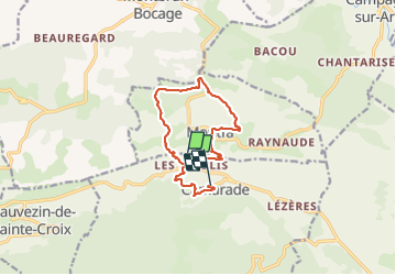

17,2 km | 24 km-effort


Gebruiker


Gratisgps-wandelapplicatie
 SityTrail
IGN / Geografische instituten
SityTrail World
De wereld gaat voor u open
Tocht Stappen van 11,8 km beschikbaar op Occitanië, Ariège, Camarade. Deze tocht wordt voorgesteld door pidjam.
Attention cette randonnée n'est plus faisable (barrage au hameau Berdot où les chemins ont été volontairement bloqués et les signalisations enlevées à la gouge dans les arbres); le chemin de petite randonnée ne peut plus passer de ce côté là.

Mountainbike
Stappen
Te voet

Paard

Paard

Te voet

Stappen
Stappen
Stappen