


michelbach

jcschubnel
Gebruiker
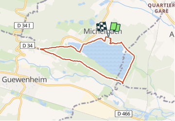

Lengte
6,6 km

Max. hoogte
375 m

Positief hoogteverschil
81 m
Km-Effort
7,7 km

Min. hoogte
328 m

Negatief hoogteverschil
87 m
Boucle
Ja
Datum van aanmaak :
2021-10-25 12:45:02.772
Laatste wijziging :
2021-10-25 16:20:32.379
2h15
Moeilijkheid : Medium

Gratisgps-wandelapplicatie
 SityTrail
IGN / Geografische instituten
SityTrail Plus
De wereld gaat voor u open
Over ons
Tocht Stappen van 6,6 km beschikbaar op Grand Est, Haut-Rhin, Aspach-Michelbach. Deze tocht wordt voorgesteld door jcschubnel.
Plaatsbepaling
Land:
France
Regio :
Grand Est
Departement/Provincie :
Haut-Rhin
Gemeente :
Aspach-Michelbach
Locatie:
Michelbach
Vertrek:(Dec)
Vertrek:(UTM)
359353 ; 5291539 (32T) N.
Opmerkingen