


2021-10-27_20h09m15_2021-10-27_539539251_Route de la Gineste – Port Pin Circuit à partir de Carpiagne

HG74250
Gebruiker
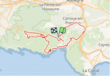

Lengte
44 km

Max. hoogte
395 m

Positief hoogteverschil
1052 m
Km-Effort
58 km

Min. hoogte
5 m

Negatief hoogteverschil
1054 m
Boucle
Ja
Datum van aanmaak :
2021-10-27 18:09:16.581
Laatste wijziging :
2021-10-27 18:40:42.095
3h59
Moeilijkheid : Zeer moeilijk

Gratisgps-wandelapplicatie
 SityTrail
IGN / Geografische instituten
SityTrail Plus
De wereld gaat voor u open
Over ons
Tocht Mountainbike van 44 km beschikbaar op Provence-Alpes-Côte d'Azur, Bouches-du-Rhône, Cassis. Deze tocht wordt voorgesteld door HG74250.
Plaatsbepaling
Land:
France
Regio :
Provence-Alpes-Côte d'Azur
Departement/Provincie :
Bouches-du-Rhône
Gemeente :
Cassis
Locatie:
Unknown
Vertrek:(Dec)
Vertrek:(UTM)
705686 ; 4789521 (31T) N.
Opmerkingen