


2021-10-27_20h13m28_pas-d-ouillier-ceyreste (1)

HG74250
Gebruiker
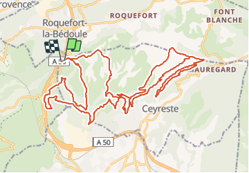

Lengte
35 km

Max. hoogte
487 m

Positief hoogteverschil
1325 m
Km-Effort
53 km

Min. hoogte
101 m

Negatief hoogteverschil
1353 m
Boucle
Ja
Datum van aanmaak :
2021-10-27 18:13:32.964
Laatste wijziging :
2021-10-27 18:36:19.011
3h40
Moeilijkheid : Zeer moeilijk

Gratisgps-wandelapplicatie
 SityTrail
IGN / Geografische instituten
SityTrail Plus
De wereld gaat voor u open
Over ons
Tocht Mountainbike van 35 km beschikbaar op Provence-Alpes-Côte d'Azur, Bouches-du-Rhône, Ceyreste. Deze tocht wordt voorgesteld door HG74250.
Plaatsbepaling
Land:
France
Regio :
Provence-Alpes-Côte d'Azur
Departement/Provincie :
Bouches-du-Rhône
Gemeente :
Ceyreste
Locatie:
Unknown
Vertrek:(Dec)
Vertrek:(UTM)
710453 ; 4790261 (31T) N.
Opmerkingen