


SityTrail - 26/06/2019 - SION LES MINES OUEST ET EST.Virtuel

chasle
Gebruiker
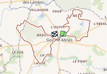

Lengte
24 km

Max. hoogte
83 m

Positief hoogteverschil
195 m
Km-Effort
27 km

Min. hoogte
20 m

Negatief hoogteverschil
198 m
Boucle
Ja
Datum van aanmaak :
2021-10-28 16:17:57.419
Laatste wijziging :
2021-10-28 16:35:10.667
6h09
Moeilijkheid : Gemakkelijk

Gratisgps-wandelapplicatie
 SityTrail
IGN / Geografische instituten
SityTrail Plus
De wereld gaat voor u open
Over ons
Tocht Stappen van 24 km beschikbaar op Pays de la Loire, Loire-Atlantique, Sion-les-Mines. Deze tocht wordt voorgesteld door chasle.
Plaatsbepaling
Land:
France
Regio :
Pays de la Loire
Departement/Provincie :
Loire-Atlantique
Gemeente :
Sion-les-Mines
Locatie:
Unknown
Vertrek:(Dec)
Vertrek:(UTM)
605552 ; 5287773 (30T) N.
Opmerkingen