


Vieux_Castillon,_Pic_Garuche-13885429-1635535143-936

Renefrt
Gebruiker
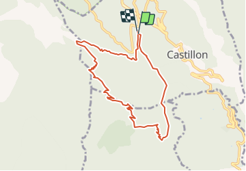

Lengte
9,2 km

Max. hoogte
1188 m

Positief hoogteverschil
520 m
Km-Effort
16,2 km

Min. hoogte
703 m

Negatief hoogteverschil
526 m
Boucle
Ja
Datum van aanmaak :
2021-10-29 19:19:13.0
Laatste wijziging :
2021-10-29 19:19:24.395

Gratisgps-wandelapplicatie
 SityTrail
IGN / Geografische instituten
SityTrail Plus
De wereld gaat voor u open
Over ons
Tocht van 9,2 km beschikbaar op Provence-Alpes-Côte d'Azur, Alpes-Maritimes, Castillon. Deze tocht wordt voorgesteld door Renefrt.
Plaatsbepaling
Land:
France
Regio :
Provence-Alpes-Côte d'Azur
Departement/Provincie :
Alpes-Maritimes
Gemeente :
Castillon
Locatie:
Unknown
Vertrek:(Dec)
Vertrek:(UTM)
376200 ; 4854904 (32T) N.
Opmerkingen