


Tregastel

aemilon
Gebruiker
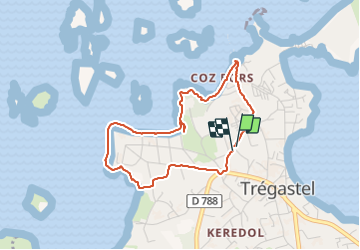

Lengte
3,5 km

Max. hoogte
28 m

Positief hoogteverschil
37 m
Km-Effort
4 km

Min. hoogte
0 m

Negatief hoogteverschil
38 m
Boucle
Ja
Datum van aanmaak :
2021-10-31 14:21:29.0
Laatste wijziging :
2021-10-31 15:35:51.061
1h14
Moeilijkheid : Gemakkelijk

Gratisgps-wandelapplicatie
 SityTrail
IGN / Geografische instituten
SityTrail Plus
De wereld gaat voor u open
Over ons
Tocht Stappen van 3,5 km beschikbaar op Bretagne, Côtes-d'Armor, Trégastel. Deze tocht wordt voorgesteld door aemilon.
Plaatsbepaling
Land:
France
Regio :
Bretagne
Departement/Provincie :
Côtes-d'Armor
Gemeente :
Trégastel
Locatie:
Unknown
Vertrek:(Dec)
Vertrek:(UTM)
462211 ; 5408593 (30U) N.
Opmerkingen