


SityTrail - VTT causse noir St Andre Vezines

Gpoujade
Gebruiker
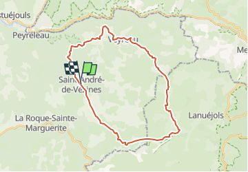

Lengte
32 km

Max. hoogte
994 m

Positief hoogteverschil
633 m
Km-Effort
40 km

Min. hoogte
786 m

Negatief hoogteverschil
643 m
Boucle
Ja
Datum van aanmaak :
2021-11-03 17:11:10.769
Laatste wijziging :
2022-06-30 15:58:02.816
2h47
Moeilijkheid : Moeilijk

Gratisgps-wandelapplicatie
 SityTrail
IGN / Geografische instituten
SityTrail Plus
De wereld gaat voor u open
Over ons
Tocht Mountainbike van 32 km beschikbaar op Occitanië, Aveyron, Saint-André-de-Vézines. Deze tocht wordt voorgesteld door Gpoujade.
Plaatsbepaling
Land:
France
Regio :
Occitanië
Departement/Provincie :
Aveyron
Gemeente :
Saint-André-de-Vézines
Locatie:
Unknown
Vertrek:(Dec)
Vertrek:(UTM)
520581 ; 4888880 (31T) N.
Opmerkingen